Took part in The Mountaineer’s annual Mountainfest yesterday, and snowshoe-bushwhacked up the shoulder of Round Mountain, where we got this view of the Dix Mountain range of the High Peaks.
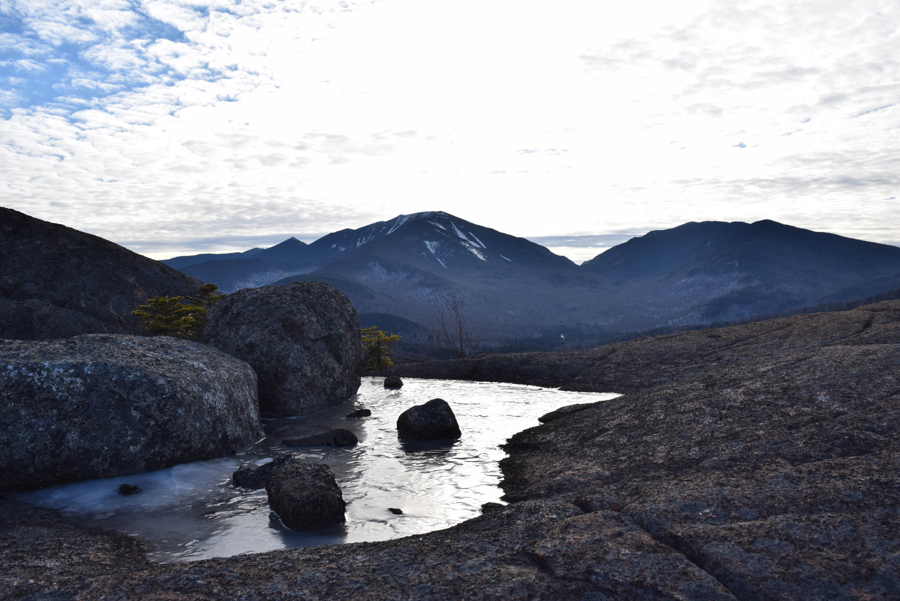
Took part in The Mountaineer’s annual Mountainfest yesterday, and snowshoe-bushwhacked up the shoulder of Round Mountain, where we got this view of the Dix Mountain range of the High Peaks.

Debris pile at outflow of Avalanche Lake
During the second or third year of my tenure in Jacksonville, FL, Tropical Storm Faye came through the area and dumped a bunch of rain. Nothing much happened other than some flooding in a few neighborhoods. But since Jacksonville sits at sea level and has an enormous river running smack through the middle of it, the flooding was nothing new or unique. Or even all that dangerous.
Then, during the summer of 2011, on a beautiful August Saturday in Upstate New York, I got a phone call from the regional office telling me that we had to evacuate the campground due to Hurricane Irene, which was steaming up the Eastern Seaboard and heading straight for us. You can imagine my dread at having to kick about a thousand people out of Ausable Point on a gorgeous day in the middle of their vacations because of a hurricane. Surprisingly, we really didn’t run into any trouble as everyone seemed to be comforted by the fact that they were going to get a refund and come back after the storm had passed. But here I was, in beautiful Upstate New York, and for the first time, I was a little worried about a hurricane.

Medium-sized moose track
When Irene finally reared her ugly head, she was a monster. Hundreds of miles of roads were washed away, houses, businesses, and buildings were knocked off their foundations and thousands of people were without power for anywhere from a day to more than a week. Ausable Point did not escape the destruction. The campground was without power for a full week and there were dozens of trees knocked down. I counted about 175 rings in one red pine.
The severity of the storm tested the resources of the state and utility companies. It took about a week for everyone to wrap their heads around what had just happened. Irene dumped more than eleven inches of rain in less than 24 hours. It was somewhere in the neighborhood of a 500-year flood.
The Eastern High Peaks Wilderness and the Dix Mountain Wilderness got hit the hardest out of the wild areas up here. High winds and the torrential downpours guaranteed a changed backcountry landscape as soon as anyone could penetrate it to find out. The wilderness areas had been evacuated, but there were still a few people who stayed (and were allowed to stay) in the woods. The ADK crew at Johns Brook Lodge and the state caretaker at Marcy Dam were a few of the brave people out there. When the storm was over, there were dozens of new landslides, huge stretches of trails were gone and bog and stream bridges were reduced to kindling. There was debris stuck in tree branches ten feet off the ground. The magnitude of the damage was staggering.
Needless to say, after the storm, all resources went to helping the people and towns that had been slammed by the flooding. Once the heavy cleanup was done and there was some breathing room, the state started to tackle the problem of the High Peaks. Labor Day was coming up, and it is always a big hiking and tourist weekend, and the state desperately wanted to make sure that the trails were safe so the public could enjoy them (and out-of-towners could help defray the cost with their tourist bucks).

Lake Colden Interior Outpost
Since I love to hike and am certified to run a chainsaw (and already work for the state), I was tapped to do emergency trail crew for a week. Actually it was more like a blitz than a crew. Close to one hundred people assembled at the Mount Van Hovenburg Ski Center for debriefing. I was told to show up and got no other information. Worried that I would be under-prepared for whatever it was we were about to do, I packed for a four-day, three-night stay in the woods. Tent, food, sleeping bag, clothes, etc., plus all my chainsaw gear, including heavy boots, chaps, and a hardhat. When I got there, only a few people seemed to have more than a day pack.

Mt. Colden from the Flowed Lands
Seeing my enormous amount of gear, two of the guys in charge pulled me from a crew that was doing day hikes and put me in with four other people who were going to stay in the woods for the four days. I found out that we would be staying at the Lake Colden Interior Outpost and that I didn’t need my tent or a couple of other things. I still had a ton of stuff in my bag and it was topping out at about 45 pounds, plus I had to wear my hardhat and carry a chainsaw and a two and half gallon jug of gasoline. This was by far the heaviest pack I had carried in a long time, if not ever, and we had a 6.5 mile hike through some of the roughest backcountry terrain in the state.
Leaving the Adirondack Loj trailhead and heading south, we were going to have to hike about 3.5 miles to Marcy Dam (the dam and bridge were wiped out by the storm) and then through Avalanche Pass on to Lake Colden. It was going to be a rough hike, but luckily the four other people I had just met and agreed to go into the woods with were turning out to be really friendly folks. But, as our individual paces strung us out along the trail, I had plenty of time to wonder just what I had gotten myself into.
I had never hiked through Avalanche Pass, and I knew the reputation was rough. And that was before it had gotten hit by a hurricane and a bunch of new landslides. Winding my way over boulders the size of school buses and using ladders and planks to navigate around them in wet conditions would have been bad enough, but I was extra top heavy due to the massive pack on my back and I also didn’t have either hand free due to the saw and fuel. I was glad Pico had not been invited on this trip.

Looking up Avalanche Lake
Then we got to the Hitch-Up-Matilda’s, a series of boardwalks attached to the cliff face about half way down Avalanche Lake. The cliffs drop straight into the water for a stretch of several hundred yards, and way back in the day, metal supports were drilled into the cliff and 2×6 planks were attached so that hikers didn’t have to swim that portion of the “trail.” The lake got so high during the flooding from Irene that most of the planks had floated off the supports (even though they were bolted on) and were MIA (as we walked over them, the planks were about four feet above water level). After negotiating the missing planks and climbing over a massive debris pile at the south end of the lake, we made our way for the last mile or two over and around more than 20 bog bridges that we would be repairing and replacing during the week.
When we finally got to the cabin, I was ticked. I had lugged a bunch of gear and bad food this far into the woods because I figured that we’d be roughing it, and there stands a two-story log cabin with a propane fridge and stove, and even running water. This place was a six and a half mile walk into the woods and it is far nicer than the one room hovel I currently reside in. We let ourselves in and relaxed for a few minutes before our crew leader Bob joined us. He left about two hours after we did, and arrived at the cabin less than twenty minutes after we got there. Bob was going to be tough to keep up with.

Opalescent River
We had to put in four ten-hour days and we had a lot of trail to cover. The walk in over the missing planks and the debris pile and the bridges that had been moved was just a sample of what we’d be doing all week. Once we got the gear straightened out, we went off and cut some blowdown in the immediate vicinity, but there wasn’t too much. We only had to hike a few miles south of the cabin to clear out some trail and then two lean-tos that trees had fallen on. Oh, and we also had to upright and reset two outhouses that had tipped over. It was wonderful and fulfilling work.
Even though I was exhausted, I slept terribly that night. Dawn came early and so out of bed and into a bowl of oatmeal I went.
We backtracked from the previous day’s hike in, and headed north back to Avalanche Lake. All the moved and missing bog bridges we had passed over the day before had to be found and put back into place. A bog bridge is a really simple thing. It’s basically used in areas where the ground is wet and the bridge helps protect the trail from erosion as well as keeping hikers relatively dry. It’s constructed of four pieces of wood, all found onsite, and some heavy duty metal spikes. You pretty much just have to find two big trees (you need a log anywhere from 20 to 40 feet long and with a diameter of at least 18 inches) and split the bigger of the two right down the middle. Then you take the smaller tree and cut two 6 foot logs from it. These are the footers, and then the long, split tree is put onto the footers so that flat part of the log is facing up. The twelve inch metal spikes hold the whole thing together, and viola, you got a bridge. One that can weigh several hundred pounds. We were lucky because even though this area of the trail had essentially turned into a raging torrent during the storm, most of the bridges were intact and just had to be located and moved.
Bob and I left the others at the south end of the stretch and we headed towards the north end. Then we would meet somewhere in the middle and have lunch. It took both teams a few hours, but eventually we ran into each other and the work on that one little section of trail was done. No bridges had to be built from scratch, but all of our backs and arms were hurting from moving so many of those damn bridges. There were no outhouses in this area, so we had that going for us, which was nice.

Mt. Colden from Lake Colden
After lunch, our first project consisted of rebuilding a series of bridges that provided access to the south end of the lake and the camping area. These bridges were the same construction as the bog bridges, but they were huge. Each bridge probably weighed at least 500 pounds, and we had 9 of them to put back into place. We cut some smaller trees to use as pry-bars and got to work. It was rough going but with five people, no one had to kill themselves to get it done. The views from Lake Colden are ridiculously nice, and I took the opportunity to snap some pictures. After dinner I hopped into Cold Brook which flows right past the cabin and into Lake Colden. It was very cold water and my “bath” lasted about 40 seconds.

Debris pile midway up Avalanche Lake
The next day dawned even earlier, although I definitely slept better that second night. We walked north over all of the reset bog bridges and started to work on clearing the enormous debris pile at the outlet of Avalanche Lake. About mid-way down the lake on the eastern side of the cliffs is a famous area known as The Trap Dike. It is a huge split in the rock face that provides backcountry skiing and ice climbing in the winter and rock climbing in the summer. The whole Trap dike had been washed out, and those that had seen it before said it was totally changed. All I could notice is the immense pile of debris at the bottom of it. The rubble stretched halfway across the lake.
Bob had talked to the project coordinator and decided that three people could actually head out that day. We had completed our assignments and needed to move onto other terrain. The other three people in the crew were going to finish clearing the debris at the end of the lake, fix the Hitch-Up-Matilda’s and then grab their gear and head home. By some stroke of luck, we actually found most of the missing planks stacked at the end of the lake, so no one would have to negotiate that stretch without the boardwalk, and it made our trip out easier too.

“Treehenge”
Bob and I headed south back to the cabin and dropped some gear and picked some other stuff out. We needed to go check a little-used trail that follows the Opalescent River down to Newcomb. We bush wacked through The Flowed Lands and found that the trail was a wreck. There was so much blowdown that in some spots, the chainsaw didn’t stop running for close to an hour. We traded tanks of gas (fill the chainsaw with gas, then one person carries it and cuts until the gas is gone. Refill and switch people and duties. That way, one person doesn’t get stuck carrying the stupid chainsaw all day) and hit one cluster of trees that simply made the trail disappear. After cutting my way in and down to the main trunks of the tress, I saw that it was a cluster that had all come down together. The roots were upturned, but still attached to the trees, creating a situation where the trees were “loaded.” This means that the trees will spring back into the upright position once enough weight is removed from their tops. This is one of the most dangerous things you can cut with a chainsaw, but it had to get done. Very carefully I cut the trees and the six and a half foot tall stumps sprung back into the upright position. We should have trimmed them down closer to the ground, but decided to leave it as a sort of monument to future hikers that we dubbed “Treehenge.”
Bob made one of the finest meals I have ever eaten that night, even though the two of us basically had to sleep in a self-created methane gas chamber. It’s amazing to me how much better food tastes when you’ve earned it. (The best meal I’ve ever had was instant mac and cheese with tuna in it on the summit of Algonquin Mountain. Disgusting, I know, but oh so delicious that day.) On the fourth morning, Bob and I set out from the cabin with all of our gear, plus some that the others had had to leave behind and started walking north towards Marcy Dam. There was a little bit of work to be done there, and then we were free to head home.

Hanging Spears Falls
We fixed the high water crossing over Phelps Brook. Yes, the high water bridge with close to five feet of clearance had been moved a few feet even though it weighed about 1000 pounds. We got some help from a summer intern and reset the bridge. Then Bob and I headed out for the three and a half mile hike back to our cars. Bob is a ridiculously fast hiker, and I gave up trying to keep up. My pace was definitely off due to the hard work and thirty or so miles of trail that we had covered in the last few days. Plus, the reduced weight in my pack from all the food I had eaten was offset by the extra gear I was carrying. But he would stop and wait to make sure I hadn’t died and then we’d move on.
It was great to get a cup of chocolate after hiking in the rain all day, and when we were done with our debriefing at the central office, I headed home, looking forward to a very long and hot shower. When I walked in the door, I knew I smelled bad, but my roommate looked at me and said: “You smell like woodchips and gasoline.” It was one of the best compliments I’ve ever gotten.
* I changed Bob’s name just because I didn’t get to ask if they wanted their actual name used.
Forecasters, meteorologists, weathermen, whatever you call them, I label them all the same: Useless.
Heading out from Ausable Point with a belly full of banana bread, I drove down to Newcomb, and then to the Elk Lake parking area after work. The plan was to hike in a little over two miles to the Slide Brook lean-to, then the next day head up into the Dix Range to climb Macomb, East Dix, South Dix, Hough, and Dix.
When I got to the parking lot, I spoke with two separate groups that both said the lean-to was full. I was worried about the forecast, which said rain starting late that night and continuing through the next day, and I didn’t bother to bring a tent. So I decided to sleep in the car and get an early start. “It’s only a couple of extra miles, and those groups did the range as a day hike, so I won’t have any problem.” Stupid forecasters.
I woke up early and started to hike, with a much lighter load. I didn’t need my sleeping stuff, so I ditched it and headed up the trail. The first miles were an easy, pretty flat grade, and I covered the distance to the herd path in under an hour. The herd path up the first four mountains (trail-less) started right from the lean-to, and to my chagrin, there were only four people sleeping there, which is considerably less than full. But oh well, it was less than three miles.
I had planned on the rain, and Pico’s ability to drink from the thousands of puddles that the rain would create. But so far, there was no rain, which of course was good for hiking, but bad for our water supply.
Heading up the herd path following Slide Brook, Pico and I made pretty good time. After starting at about 6:30am, we reached the base of the rock slide on Macomb in just a hair under two hours. Pico and I had never hiked up a rock  slide before, and I have to tell you, it was a hell of a lot more scary than I had imagined. I got the first glimpse of the slide a little before reaching the base, and quickly realized that it was close to a thousand feet long, and probably gained six or seven hundred feet in elevation. Staring up from the base of the slide, I was taken aback at how loose and sandy it was. There were some pretty big rocks and lots of smaller ones, with no discernible path up it.
Pico, of course, immediately started up the slide without any hesitation. I, on the other hand, gingerly started to pick my way up, occasionally having to use hand and feet holds, and sending loose rocks sliding with any small slip of my foot. The going was kind of slow, but not too bad, and after getting about halfway up the slide, the first views of Elk Lake were reassuring. It sure did seem pretty far away, though. I was also really preoccupied with the stability of the slide. I thought about avalanche safety, and never crossing the slide, but it was unavoidable. There were several times when I thought about just how screwed I would be if me or Pico started to fall. There wasn’t going to be any way to stop until gravity decided to cut me a break.
 After topping out on the slide with no major problems, the trail started again and we were on the summit of Macomb pretty quickly. The clouds were just sitting on top of the mountains, and with no view of the four other peaks on the agenda, I got out the compass and got a bearing towards South Dix. Luckily, the trail was again easy to follow, and Pico and I had no problem making our way to the summit of South Dix.
Just below the summit of South Dix, I ran into a couple who were hiking the other way. They had gone up Dix, then over Hough, camped out, and were exiting over South Dix and Macomb. They said the trail to Hough was easy enough to find, but the two groups who told me the lean-to was full had both gotten lost on their way to Hough. By now the clouds had lifted and I got my first view of what Pico and I had already climbed and what we still needed to climb. We were on the summit of the second of our five mountains for the day, and it was already 10:20am. Better get a move on…
 Leaving the summit of South Dix, the trail follows the ridge between South Dix and East Dix. It was easy going, but due to the distance, it took close to an hour to get there. And of course, we then had to turn around and re-hike the same ridge to climb South Dix again. Looking up at the hogback, Hough, and then the small summits leading up to Dix was intimidating. They look so close together, but I know that we still have a lot of walking to do. Plus, our water was getting low because I had to keep sharing it with Pico. Not a single friggin’ puddle for him to drink from. Stupid weathermen.
Not sure how those two groups I spoke to the day before missed the trail to Hough, but Pico and I found it with no problem. We started off to climb the three hump hogback between South Dix and Hough. After getting over the hogback, the ridge drops to just below 4000’ in elevation, so there is a campsite there. Nice little spot, and you’re pretty much guaranteed privacy since it’s in the middle of nowhere.
A steady climb brought us up to the summit of Hough a little after 1:00pm. By  now, the sun had peaked out a couple of times, and I was, again, rationing water for Pico and myself. I was starting to be thirsty all the time, and Pico was lapping up every drop I gave him. We had a quick lunch of bagels and I took off my clothes to let them dry out a little and soak up some sun. The summit of Hough was kind of lackluster in and of itself, but there were some great views, especially of Dix, South Dix and Macomb, even with the clouds still sitting pretty low.
Climbing over the three sub-peaks to get to the summit of Dix was demoralizing. I was thirsty and tired, but I also knew that the fastest way back to the car was to climb Dix and head out on the main trail, just like I planned. So we pressed on, and the trail was still easy to follow, but considerably harder to hike. The steepness of some of the sections made me a little worried if I had to down climb, but soon we were right near tree-line, and it seemed like the summit was near. The trail then led us to a giant boulder with a thirty foot long crack in the middle of it. I couldn’t believe my eyes. I searched around for a path around the boulder, but found none. I figured that I could try to climb it and maybe it looked worse than it was. I finally got up into the crack and made it up about halfway, then looked back at Pico and realized he wasn’t going to be able to follow me up, and the only rope I had was some flimsy clothes line, not strong enough to pull him up. I down climbed and then bushwhacked my way around to the left of the boulder. The trees were thick and stiff, and it took close to twenty minutes to go about thirty feet. But, Pico was able to follow on this route, and we made it to the top of the boulder.
Surprisingly, we popped out on the main trail maybe two minutes later. Hiking another quarter mile of so, we reached the summit of Dix, the fifth and final  High Peak of the day.
The hike out was uneventful to say the least. Pretty much a straight shot out to the car, even though it took another four hours of walking. Just as I was able to see the parking lot through the trees, I felt the first sprinkle of the day. We got to the car, and I drank water until I almost threw up. As the sprinkles got a little heavier, I stripped for the second time that day and took a rain shower right there in the parking lot.

First stream crossing
Earlier this year, I hiked Lyon Mountain for the second time. It was a warm-up for the next week when I hiked Cascade and Porter. Lyon Mountain is not one of the High Peaks, but it’s close at 3830 feet in elevation. The nice thing about Lyon is that it sits all by itself on the Northeast edge of the Adirondack Park. From the summit on a clear day you can see Vermont, the High Peaks and the skyline of Montreal.
The mountain also has a long history and even some intrigue about it. For a long time, Lyon Mountain was one of the biggest iron ore operations around. It has hosted a ski area, fire tower, caretaker’s cabin, and possibly even some nuclear missile silos.
The trail up Lyon Mountain was recently redone and now includes more switchbacks and a few new bridges. The trailhead (N 44.72386, W073.84167) is at the end of a dirt road off of the Chazy Lake Road at the site of the former Lowenburg Ski Area (Lowenburg… Huh, wonder if they were Jewish?). It actually showed up as Lowenburg Road on my GPS. From Route 3 in the town of Saranac, turn onto the Chazy Lake Road. Continue straight through the first Stop sign. Be sure to wave to everyone you see, and then bear left at 0.5 miles. Turn right at 2.3 miles at the Four-Way Stop. Get your first view of the summit and fire tower at 3.5 miles. Turn left onto the dirt road at 7.9 miles. There is a brown wooden sign hanger at the road, but no sign. Coming up the road, park on the right and the trailhead is in the far left corner of the clearing.

Red trillium on the Lyon Mtn. trail
For the first ten minutes or so, the trail is nice and wide. (If you’re a backcountry skier, then follow the trail straight here to the top of the old ski trails and have a great time on your way down!). The trail is well marked with red plastic discs. Bear left onto the single track and make the first stream crossing on one of the new bridges. The forest makes a nice change here to an understory of witchhobble and trillium with a maple canopy.
Make the second stream crossing after a nice rolling stroll and then about a half mile later, get a view of Chazy Lake to your left. The summit push is pretty steep, but I only had to use my hands to scramble once or twice. I did run into a large sheet of ice on the trail that I had to avoid, because I wasn’t prepared for ice, you know, because it was May 20th. Reaching the fire tower, find the highest rock you can, and that’s the summit!
The summit is open with an almost 360 degree view. Try to stay on the rocks and off the soil while hopping around. And if you make it up more than three flights of the fire tower, you’re more brave than I am.

Fire Tower on Summit of Lyon Mtn. summit
Looking to the North from the summit, you can see the Altona wind mill area, and Montreal on a clear day. To the southwest, you can see the High Peaks and to the East lies Vermont and the Green Mountains. The trail up Lyon is not an easy one, but it’s not a killer either.
As I said before, this was the second time I climbed Lyon. The first time was in 2008 in preparation for climbing a couple of High Peaks, the same reason I did it this time. But soon I will have to climb it just for it’s own sake, because it’s a great hike.