
First stream crossing
Earlier this year, I hiked Lyon Mountain for the second time. It was a warm-up for the next week when I hiked Cascade and Porter. Lyon Mountain is not one of the High Peaks, but it’s close at 3830 feet in elevation. The nice thing about Lyon is that it sits all by itself on the Northeast edge of the Adirondack Park. From the summit on a clear day you can see Vermont, the High Peaks and the skyline of Montreal.
The mountain also has a long history and even some intrigue about it. For a long time, Lyon Mountain was one of the biggest iron ore operations around. It has hosted a ski area, fire tower, caretaker’s cabin, and possibly even some nuclear missile silos.
The trail up Lyon Mountain was recently redone and now includes more switchbacks and a few new bridges. The trailhead (N 44.72386, W073.84167) is at the end of a dirt road off of the Chazy Lake Road at the site of the former Lowenburg Ski Area (Lowenburg… Huh, wonder if they were Jewish?). It actually showed up as Lowenburg Road on my GPS. From Route 3 in the town of Saranac, turn onto the Chazy Lake Road. Continue straight through the first Stop sign. Be sure to wave to everyone you see, and then bear left at 0.5 miles. Turn right at 2.3 miles at the Four-Way Stop. Get your first view of the summit and fire tower at 3.5 miles. Turn left onto the dirt road at 7.9 miles. There is a brown wooden sign hanger at the road, but no sign. Coming up the road, park on the right and the trailhead is in the far left corner of the clearing.

Red trillium on the Lyon Mtn. trail
For the first ten minutes or so, the trail is nice and wide. (If you’re a backcountry skier, then follow the trail straight here to the top of the old ski trails and have a great time on your way down!). The trail is well marked with red plastic discs. Bear left onto the single track and make the first stream crossing on one of the new bridges. The forest makes a nice change here to an understory of witchhobble and trillium with a maple canopy.
Make the second stream crossing after a nice rolling stroll and then about a half mile later, get a view of Chazy Lake to your left. The summit push is pretty steep, but I only had to use my hands to scramble once or twice. I did run into a large sheet of ice on the trail that I had to avoid, because I wasn’t prepared for ice, you know, because it was May 20th. Reaching the fire tower, find the highest rock you can, and that’s the summit!
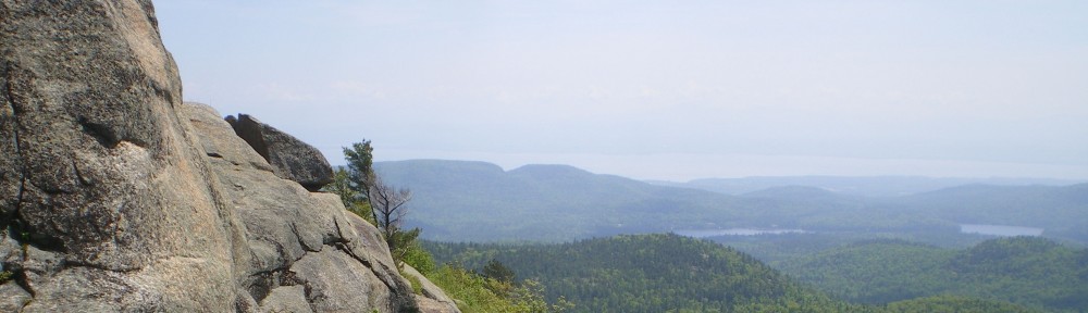
The summit is open with an almost 360 degree view. Try to stay on the rocks and off the soil while hopping around. And if you make it up more than three flights of the fire tower, you’re more brave than I am.

Fire Tower on Summit of Lyon Mtn. summit
Looking to the North from the summit, you can see the Altona wind mill area, and Montreal on a clear day. To the southwest, you can see the High Peaks and to the East lies Vermont and the Green Mountains. The trail up Lyon is not an easy one, but it’s not a killer either.
As I said before, this was the second time I climbed Lyon. The first time was in 2008 in preparation for climbing a couple of High Peaks, the same reason I did it this time. But soon I will have to climb it just for it’s own sake, because it’s a great hike.
Wow, the view must be great from up there.